Explicitly designed for innovative architects and inspired designers, this first-of-its-kind tool allows for the easy and direct import of three-dimensional models into the Simplex 3D platform. With seamless integration, the plugin accurately preserves the realistic details of model components and their rendering properties, ensuring that architects and designers never have to compromise design integrity for context.
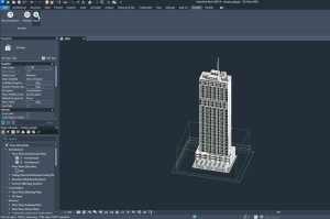
This plugin empowers architects and designers to deliver exceptional quality and contextual data, elevating projects to new heights. Simplex 3D’s commitment to excellence is showcased by revolutionizing traditional design processes. Exporting and updating models between Revit and the Simplex 3D platform enhances workflow agility. With a simple ‘Export’ click, changes in Revit are seamlessly incorporated, keeping your model up-to-date and saving time on manual adjustments.
This transformative solution makes it even more efficient for architects and designers to visualize, plan, and build the future using high-resolution 3D models.
Cracking the Code: Mastering the Architectural Challenge
In the rapidly evolving architectural landscape, architects and designers face a multitude of challenges that often feel, and in reality, are, isolating. Tight deadlines, the need to maintain design integrity, and the growing requirement for effective collaboration create a complex environment for both architects and designers, which can dramatically impact project quality. The Revit plugin is the ultimate tool for overcoming these hurdles and empowering the architectural design journey to navigate through novel dimensions.
The innovative solution streamlines workflows and empowers the creative vision by simplifying the import of 3D models into the Simplex 3D platform. By unlocking limitless design possibilities and enhancing project efficiency, Simplex 3D’s Revit plugin helps professionals stay competitive in a rapidly changing industry, effectively tackling complex architectural challenges to make more informed decisions.
The Future of Architectural Intelligence is Here
The Simplex 3D plugin enhances the experience for professional users by allowing architects to easily export their detailed 3D models to the Simplex 3D platform. The plugin removes the guesswork, streamlines workflows, and significantly reduces frustrating back-and-forth communication between different design platforms by utilizing enriched contextual data from real urban environments, fostering a shared understanding, and ensuring team alignment.
The seamless integration preserves all the realistic details of the model components along with their rendered properties. Exporting and updating models between Revit and the Simplex 3D platform boosts workflow efficiency. With just a simple click on ‘Export,’ any tweaks or changes made in Revit are seamlessly incorporated, keeping the models up-to-date and reducing the need for monotonous manual adjustments. As a result, the integrity of the designs is maintained, giving architects and designers complete confidence in their outcomes.
Quality Meets Context
The Simplex 3D plugin addresses the longstanding challenge of harmonizing design quality with contextual accuracy. It ensures that all project materials, including textures and metadata, are preserved with unparalleled accuracy. This enables architects and designers to create stunning photorealistic and interactive 3D models that vividly come to life within detailed urban environments, enabling professionals to step entirely into a new dimension. Architects and designers can explore planning alternatives to achieve better decisions faster. This improvement enhances the crucial visual storytelling element within architectural presentations, making designs resonate within their intended context.
The First of Its Kind
Simplex 3D proudly stands at the forefront of architectural solutions and unparalleled 3D visualization as Simplex 3D introduces the very first plugin specifically crafted for 3D architectural design. This pioneering tool equips architects with powerful features that enhance project management and foster a collaborative spirit. Key functionalities include version control and customizable permissions, allowing diverse teams of stakeholders to work in harmony while maintaining design integrity in a private workspace on the cloud.
Enhanced Collaboration and Efficiency
One of the standout features of the Simplex 3D plugin is its remarkable ability to enhance collaboration. After exporting designs, sharing them with clients, team members, and other stakeholders becomes effortless. Integrated permissions and version control improve communication and manage model revisions effectively, safeguarding sensitive information while uplifting productivity across the board. With a collective perspective, accelerated approvals and enhanced showcasing can be achieved.
Take Revit Projects to the Next Level
Ready to elevate Revit projects? Discover the innovative features of the Simplex 3D plugin by visiting the Autodesk plugin page. Learn how Simplex 3D can transform architectural workflows and help architects and designers design with context and confidence while embracing the future of precise and comprehensive architectural innovation within the urban context.
 (1)")


Strategic relationship augments Simplex 3D’s new 3D modeling of Greater New York Metro with First American’s industry-leading data assets.
NEW YORK–(BUSINESS WIRE)–Simplex 3D, a leading global platform provider for urban planning, announced its expansion into the United States, and a strategic relationship with First American Title Insurance Company, one of the largest title insurers in the nation and the principal subsidiary of First American Financial Corporation (NYSE: FAF). Simplex 3D’s technology enables developers, architects, urban planners, real estate professionals, and other B2B and B2G clients and partners to operate an intuitive 3D private workplace with state-of-the-art tools and functionality.
Simplex 3D offers one of the world’s highest-resolution, up-to-date reproductions of the greater New York Metro area. Equipped with property, financial, and other geographic data and information layers, advanced visualization capabilities, and professional-grade tools, Simplex 3D’s platform offers real estate stakeholders the ability to explore, plan, and collaborate in their own spatial reality. Other unique features include accurate engineering measurement, shadow analysis at any time throughout the year and time of day, the ability to import architectural models, and ascertain the view from every window in the present and future.
The strategic relationship reinforces First American’s technology and innovation leadership in title insurance and mortgage industries. Through the strategic relationship, First American will leverage the Simplex 3D platform to augment automation efforts and accelerate informed analysis, forecasting, and decision-making. In turn, Simplex will leverage industry-leading data assets from First American Data & Analytics to further enhance Simplex 3D’s platform, offering clients in-depth insights and a detailed 360° virtual assessment of targeted assets and their surroundings.
“Advanced technologies, like Simplex 3D’s platform, can be a significant growth engine for the entire real estate ecosystem,” said Brian Tormey, multi-state manager for First American Title’s Direct Division and the president of TitleVest, a member of the First American family of companies. “Simplex 3D’s easy-to-use SaaS-based platform will bring added value to our customers, empowering high-stake decision-making with accuracy within a photorealistic interactive map and broadening the products and services we offer.”
Simplex 3D’s Co-Founder and CEO, Avi Aflalo, commented, “We are honored to combine forces with First American. Our extensive experience and expertise in the real estate sector empower us to collaborate closely and redefine the industry’s future by introducing cutting-edge technology—a uniquely collaborative tool for real estate professionals.” Aflalo added, “The celebration of our relationship and launch in New York are major milestones for Simplex 3D, and we look forward to accomplishing much more with First American.”
Simplex’s strategic U.S. channel partner, FTPT, initiated and structured the strategic relationship between Simplex 3D and First American.
About First American Title Insurance Company
First American Title Insurance Company, the largest subsidiary of First American Financial Corporation (NYSE: FAF), traces its history to 1889. One of the largest title insurers in the nation, the company offers title services through its direct operations and an extensive network of agents throughout the United States and abroad. First American Title provides comprehensive title insurance coverage and professional services for real estate purchases, construction, refinances and equity loans. For more information, visit www.firstam.com/title.
About First American Financial Corporation
First American Financial Corporation (NYSE: FAF) is a premier provider of title, settlement and risk solutions for real estate transactions. With its combination of financial strength and stability built over more than 135 years, innovative proprietary technologies, and unmatched data assets, the company is leading the digital transformation of its industry. First American also provides data products to the title industry and other third parties; valuation products and services; mortgage subservicing; home warranty products; banking, trust and wealth management services; and other related products and services. With total revenue of $6.0 billion in 2023, the company offers its products and services directly and through its agents throughout the United States and abroad. In 2024, First American was named one of the 100 Best Companies to Work For by Great Place to Work® and Fortune Magazine for the ninth consecutive year, and named one of the 100 Best Workplaces for Innovators by Fast Company for the second consecutive year. More information about the company can be found at www.firstam.com.
About Simplex 3D
Simplex 3D is a groundbreaking, global B2B SaaS 3D platform designed as a professional working tool for real estate professionals. Simplex 3D provides real-estate professionals a new perspective on reality, so that they can build their own real-estate world confidently. Our collaborative SaaS platform brings all perspectives to the forefront, giving urban planning and the real estate industry access to layers of integrated data, revealing all angles for better decision-making. With their own 3D workspace, municipalities, architects, brokers, developers, construction companies, and others, can now explore, plan and collaborate without ever leaving the platform. For more information, visit www.simplex3d.com.
This February, the Simplex 3D team embarked on an thrilling tour across New York City, marking a significant milestone in our journey to revolutionize the real estate and architectural landscape. From the 12th to the 15th, we engaged with industry professionals, showcased our cutting-edge technology, and fostered meaningful partnerships that promise to reshape the built world.
Workshops and Exclusive Launch Evening
Our journey began with targeted workshops for First American’s sales representatives, an initiative that deepened our collaboration and set the stage for what was to come. These sessions, held at First American’s offices, were instrumental in aligning our teams and showcasing the practical applications of Simplex 3D’s technology in real estate transactions.
Following the workshops, an exclusive evening hosted by our partners, First American, in their offices. This special event brought together VIPs from the real estate sector, setting a high note for the days that followed.
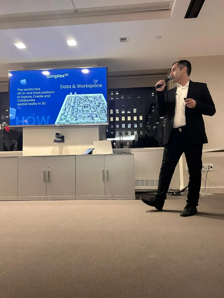
(Avi Aflalo, Simplex 3D CEO and Founder at the First American launch evening)
The enthusiasm and positive feedback we received from our partners and guests were beyond encouraging. Executives from First American and SHoP Architects, along with other industry leaders, shared their excitement about the potential of Simplex 3D to transform the real estate and architectural landscape. Their insights not only validated our efforts but also highlighted the eagerness of professionals to embrace innovation.
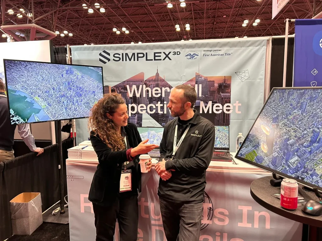
New York Build Expo
Following the launch, we participated in the huge New York Build Expo at the Javits Center, where our booth attracted a wide array of professionals. The expo provided a fantastic platform to demonstrate our technology’s capabilities, engaging attendees with the possibilities of high-resolution 3D city modeling.
A highlight of our expo participation was the panel discussion, “Stakeholder Spotlight: Unique Perspectives of How Technology and Innovation Will Disrupt the Built World in 2024.
This discussion brought together diverse viewpoints on how technology is positively impacting the real estate ecosystem, offering valuable insights into the future of the industry.
Visit to SHoP Architects
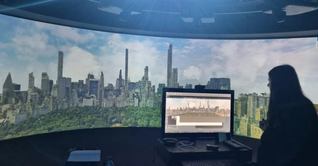
The climax of our New York tour was a visit to SHoP Architects offices. We were hosted by Todd Sigaty and John Cerone, who provided an inspiring tour of their office, including the impressive 360-degree screen room. Displaying our New York model on their panoramic screen offered an immersive view of Manhattan, showcasing the unparalleled resolution of our 3D technology. This visit highlighted the synergy between Simplex 3D and SHoP Architects and the exciting potential of our collaboration.
Looking Forward
As we reflect on our successful launch and the series of events in New York, we are filled with gratitude and anticipation for the future. We extend our heartfelt thanks to First American, SHoP Architects, and all the professionals who engaged with us during this journey.
We invite New York’s real estate and architecture professionals to explore the possibilities with Simplex 3D.
Book a demo with Simplex 3D today and discover how our platform can elevate your projects to new heights.


Jordan Kastrinsky hosts Simplex 3D co-founder and CEO, Avi Aflalo, in his popular podcast “High Tech On The Low” to chat about entrepreneurship journey, 3D and AI.
In the podcast, Avi, describe how 3D modeling has changed the way that many stakeholders operate. From engineers to city planners to even everyday citizens on their way to work, 3D technology provides a much more comprehensive, updated view of an area than ever before. Avi Aflalo, CEO and co-founder of Simplex 3D has seen his company’s solution deployed over multiple industries, in multiple countries, with great success in redefining how 3D technology can drive greater efficiency and accuracy in real estate and urban planning. Now, with AI and other developments, Avi is looking to see how to integrate them into his platform to drive the new generation of 3D planning tools.
Google Earth, a platform visited by 30 million users monthly since its 2001 launch, now offers enhanced 3D modeling of over 2,500 cities globally. Its recent API launch allows for streaming these 3D city models to external systems, potentially eliminating the need for costly aerial photography and intricate 3D modeling processes for developers. This could revolutionize the gaming industry, enabling more realistic game maps, and could fast-track new AR/VR apps for tourism, property tech, and autonomous vehicles. However, there are challenges: the platform restricts detailed ground-level views, raising quality concerns, and Google’s current terms prohibit commercial deployment of the API, with substantial data limits. Moreover, concerns linger about future costs for developers and the frequency of model updates. Google’s potential impact on the 3D industry is immense, but its future plans, especially commercial aspects, remain uncertain.
The New Google Earth 3D release for developers and gamers: is this a real revolution or just a teaser?
Who hasn’t checked out Google Earth before booking a vacation abroad to see what the hotel or resort really looks like, plan your itinerary, or take a sneak peek at destinations you probably won’t visit anytime soon? Since its launch in 2001, the Google Earth service has become super popular, with an estimated 30 million visitors per month.
Google’s 3D modeling offers an impressive coverage of around 2,500 cities across the globe, where we can visit New York, San Francisco, London, Paris, Rome, Tokyo, Moscow, Sydney, and more. But is it really a service whose entire purpose is free for would-be travelers and the curious at heart, or is there a far greater potential here?
https://www.linkedin.com/pulse/new-google-earth-3d-release-developers-gamers-real-revolution
Meeting the surge in demand for fiber optic networks – on time and on budget
To keep pace with the fast-growing adoption of fiber optic networks in Israel, and the vast number of consumers deploying fiber optics, Partner had to act fast, and quickly deploy networks in new areas throughout the country. This led to the company’s launch of its state-of-the-art Partner Fiber, and the critical need to expand its fiber optic infrastructure nationwide. “With Partner Fiber, fiber optic networks aimed at the mass market, we were able to go the ‘extra mile’ for our customers, and deliver consistent high-quality communications, at the best available speed,” said Pavel Kleiman,
Infrastructure Manager at Partner. “But, evaluating the feasibility of expanding our fiber optic networks, especially designing networks at remote sites across the country, is easier said than done.”
Partner Communications Powers Fiber Optic Network Planning with Simplex3D
Founded in 1997, and publicly-traded on the Tel Aviv Stock Exchange (TASE: PTNR), Partner Communications Company (Partner), is a leading communications operator in Israel, providing a broad range of cellular communications. With 25% of the market share, and -3 million subscribers, services include internet, cellular, fixed-line, international telephony, OTT, and IPTV. As the first operator in Israel to deploy fiber optics, Partner currently holds 33% of this market.


The Maccabiah Games: Taking Event Management to New Heights with Simplex 3D
The Maccabiah Games streamlines, optimizes, and secures nationwide sporting event with
Simplex technologies, powered by an advanced web-based 3D management solution
The Maccabiah Games is the world’s third-largest sporting event after the Olympics, and the FIFA World Cup. Inaugurated in 1932, this international multi-sports event is held in Israel every four years, with the mission of facilitating a worldwide gathering of young Jewish athletes, staging the highest levels of sporting competitions. Held under the auspices of the Maccabi World Union, the organization spans more than 450 clubs in over 70 countries on 5 continents, with 500,000 members.