Platform

The Power of 3D Planning

Site accessible?
Land Use
OFF ON
Sun Position
Plan / Build
Comment
Graphic element 1 Graphic element 2 Graphic element 3 Graphic element 4
Graphic element 6
No more guesswork; Start planning with full urban context on the world’s highest-resolution 3D workspace
1

Explore

Highest-Resolution 3D Views

Experience 360° navigation at 3cm per pixel resolution from any angle, distance, and height, to explore the urban context, conduct in-depth analysis, and collaborate on urban planning projects

Layers of Integrated data

Urban context, transportation, zoning, financial – all the data you need, contextually integrated into one place

Accurate engineering measurements

Achieve precise, levels of details on distance, height, slopes, footprint, roofs, and point-to-point

Track city development over time

Convenient split screen to view past, present and future status of urban areas with highly-accurate \current citywide/neighborhood views, and planned future land use, including approved building plans


Graphic element 1 Graphic element 2
2

Create

Plant Your Project
Plant Your Project
Plant Your Project
Import your detailed architectural plans from 3D modelling software such as Revit or Sketch
Compare Designs
Compare Designs
Compare Designs
Explore alternatives, and conduct “what if” design scenarios in minutes. Compare different structures, heights, angles and locations for your projects
Draft New Buildings
Draft New Buildings
Draft New Buildings
Simply draft new structures with polygons directly in Simplex 3D
Your Data Layers
Your Data Layers
Your Data Layers
Easily import and upload your own data layers, integrated into the system in real-time, and share your data with third-party urban planning project stakeholders
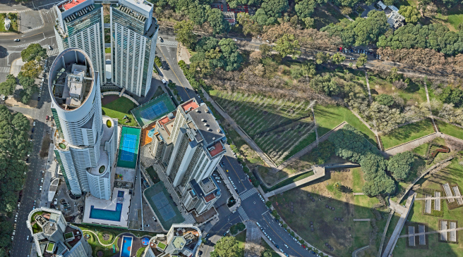
Hidden & Seen Areas
Hidden & Seen Areas
Hidden & Seen Areas
Create accurate, interactive high-resolution 3D simulations of hidden and seen areas
Sun and Shade
Sun and Shade
Sun and Shade
View sun and shade, at all hours of the day, to provide visuals of reality scenarios, and deliver more effective presentations
Graphic element 1 Graphic element 2 Graphic element 3 Graphic element 4 Graphic element 5
3

Share

Allowing for streamlined work, together. From layers of data, view points, and presentations

Bookmarks, presentations, image uploads, links, files, and additional explanations for each element of data added

Sharing a single 3D workspace with all urban planning project stakeholders, enhances communication with municipalities and customers, to speed up the arduous, time-consuming approval process

Enables project stakeholders to explore, create, and collaborate spatial reality in 3D, all via the same integrated platform, using identical tools, and speaking the same language, for better, faster decision-making
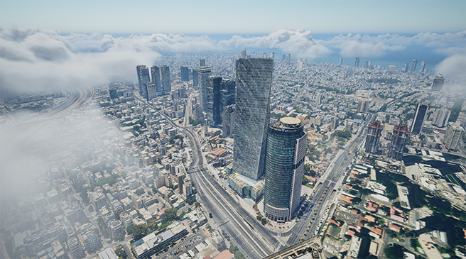
Graphic element 1 Graphic element 2 Graphic element 3

Use Cases

Architecture Architecture
Architecture
Blend prototypes into landscapes to bring your vision to life
Learn More
Urban Planning Urban Planning
Urban Planning
Insightful urban context, interactive simulations, and efficient collaboration
Learn More
Real Estate Entrepreneurs Real Estate Entrepreneurs
Real Estate Entrepreneurs
Smarten investments, spot opportunities
Learn More
Real Estate Appraisers Real Estate Appraisers
Real Estate Appraisers
Accurate evaluations in minutes
Learn More
Local Government Local Government
Local Government
Drive community engagement and streamline administration
Learn More
Security & HLS Security & HLS
Security & HLS
Full control of your sites from every perspective
Learn More
Infrastructure Infrastructure
Infrastructure
Robust planning and operations with life-like 3D views of the field
Learn More
Architecture Architecture
Architecture
Blend prototypes into landscapes to bring your vision to life
Learn More
Urban Planning Urban Planning
Urban Planning
Insightful urban context, interactive simulations, and efficient collaboration
Learn More
Real Estate Appraisers Real Estate Appraisers
Real Estate Appraisers
Accurate evaluations in minutes
Learn More
Infrastructure Infrastructure
Infrastructure
Robust planning and operations with life-like 3D views of the field
Learn More
Local Government Local Government
Local Government
Drive community engagement and streamline administration
Learn More
Security & HLS Security & HLS
Security & HLS
Full control of your sites from every perspective
Learn More
Graphic element 1

Why Simplex

The only “one-stop-shop” solution – 3D map, data and workspace on a single platform
World’s highest-available resolution 3D visualization
Comprehensive and accurate urban context – All the information you need in one location
Accelerated decision-making derived from robust analysis tools
Saves significant time, and costs – Lets you focus on your core tasks
Fast and easy to use – Get started immediately, no need for GIS knowledge